Google+ Running in Cork, Ireland: greenway
Showing posts with label greenway. Show all posts

Friday, April 03, 2026

New section of Greenway between Glenbrook and Monkstown is open - Apr 2026


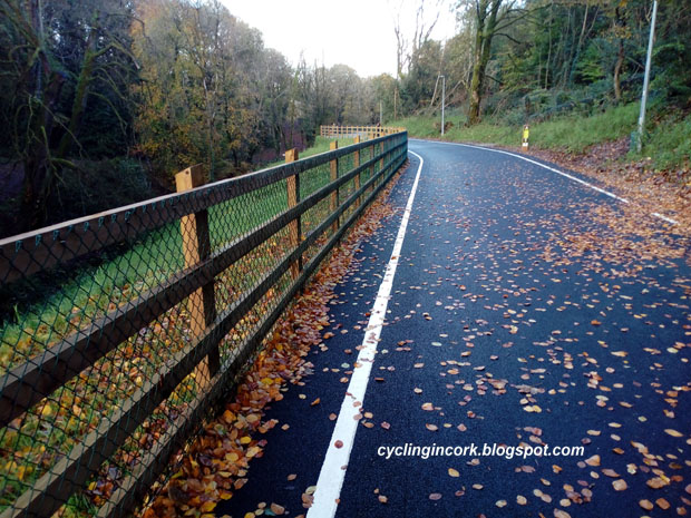
Over the last few days, contractors have been putting the finishing touches to the new greenway between Glenbrook and Monkstown and it is now finally open as can be seen in the photo above.

It's not that long but it's another step in getting a full greenway between Carrigaline and Cork City.


The map above shows the location. The bright green section is the new greenway which is about 730m in length. The dark green section is the existing narrower section which runs under the 'Cut and Cover' railway tunnel and comes out in Monkstown.


The new greenway starts at the cross harbour ferry as shown above and heads south.


The photo above shows the end of the new section and transitions onto the narrower 400m section. The 'Cut and Cover' railway tunnel can be seen in the distance and Monkstown is around the corner.

Video... The video below shows part of the new greenway starting from the car ferry...

Cork to Carrigaline Greenway... This is a map of the approximate route for the full 17.5km greenway which will go from Pairc Ui Chaoimh in Cork City to Carrigaline.


As of the Spring of 2026, there is a greenway from Cork City to Passage West which is about 8kms in length and there is a short 500m section in Carrigaline. The balance is about 9kms.

This new section from the car ferry to Monkstown reduces the undeveloped section from about 9 to 8kms. It's not a huge amount but it's another step in the overall project.

Impact???... The previous footpath was reasonably wide so the impact for walkers and runners of the new section is pretty small, it just means that there is more space. The bigger impact will be for slower cyclists in that the greenway is a lot safer than the main road for adults and children. Motorists benefit because there are fewer cyclists on the road that they need to pass.

In terms of road races, the Great Railway Run from Cork to Carrigaline and the Cork Down Syndrome charity half-marathon from Haulbowline to Pairc Ui Chaoimh use this new section of greenway.

Friday, November 07, 2025

Plans announced for new Greenway at Dunkettle Roundabout - Nov 2025


As the Port of Cork moves its operations from Tivoli to Ringaskiddy, the old docklands area is due to be redeveloped. As part of the project, there is a plan for a new greenway going from Horgans Quay to where the Dunkettle Roundabout is now. This will in turn connect to the greenways going to Glanmire and to Midleton.

The Port of Cork Company have just announced that they will be applying for planning permission in November 2025, to significantly upgrade access to and from its Tivoli Docks site in Cork City.

As part of the plan at the eastern end, the Dunkettle roundabout will be replaced with a new junction which will include a greenway. The image below shows the southern side of the new Dunkettle juntion is shown below.


The key feature of the new junction is that traffic on the N8 going east-west or west-east will pass unimpeded under a new bridge with no traffic lights.

The road above marked A is the new access road from the redeveloped Tivoli site to the new junction.

Traffic from Glanmire will pass over the new N8 bridge which will have traffic lights. They will then turn right onto the down ramp B and will merge with the N8 traffic going into the city. 

Traffic coming out of the city and heading towards Glanmire will take a slip road to the right where there will be traffic lights, very similar to what it is like at the moment.

From a walking / running / cycling point of view, there is going to be a new greenway which is highlighted above in green.

As can be seen from the image, the new greenway will come out of the city and run parallel to the railway line. It will then go under a bridge and do a small loop to gain height to cross over the junction.

The image below shows the northern side of the junction.


Traffic on the N8 flows unimpeded under the new bridge.

Traffic coming out of the city and heading towards Glanmire will use the offramp marked A which will have traffic lights.

Traffic coming from the east that wants to go to Glanmire will use the offramp marked B. The image shows two lanes turning right for Glanmire. There is one lane left for the new redeveloped Tivoli site.

Traffic coming from Glanmire heading towards the city cross over the bridge and turn right. Glanmire traffic heading east take the slip road at C and then merge with the N8 traffic.

Greenway users will have to negotiate two traffic junctions with traffic lights. The good thing here is that these are slip roads which will be no way as busy as the N8.


The image above shows the western end of the Tivoli site near Silversprings and the new greenway is shown in green.

In conclusion... That's the current plan as it stands and if it goes ahead then I'd guess that it might be something like the mid-2030's before it's built. 

Who will use the new greenway? There are plans for some 6,500 new homes in the new Tivoli site which is a town in itself and it's likely those residents will be the biggest users of the greenway.

Going off other greenways, the biggest users will be walkers with the balance split between runners and cyclists.

Tuesday, July 22, 2025

An Bord Pleanála give green light to Greenway upgrade in Passage West - July 2025


Back in November of 2024, Cork County Council published plans for the upgrade of the Greenway in Passage West in Cork Harbour... previous post HERE

 An Bord Pleanála have just given the project the green light with some minor conditions.

Cork County Council said the following about this 2km stretch... “This portion of the Cork Harbour Greenway is an important component of the strategic inter-urban cycleway connecting Carrigaline with Cork City.

The proposed route shall offer a connection to the ferry terminal facilitating access to Carrigaloe, Rushbrook, and Cobh. The proposals will see the extension along the road for pedestrians and cyclists from an average of 2.8m wide to 4m wide.

The proposal to widen the pathway will improve shared usage of the pathway by pedestrian, runners and cyclists.”

Existing Greenway

The key aspect of this upgrade is extending the width from 2.8m to 4m which will allow more space for walkers, runners and cyclists to share the greenway.

This new approval is for the greenway which is in the county. This will join onto another section which will also be upgraded and is in the city. As can be seen from the map below, this connects back to the upgraded greenway in Blackrock.


What does this mean in reality?... In the immediate term, nothing! These projects move at a glacial pace so don't expect to see any work happening soon.

In the near term... say late 2026? 2027?.. then we might see some movement. The big change for users of the greenway in Passage is that it is likely to be closed for 12-months.

The car parks at Robert's Bridge and in the town (marked in blue in the top image) will be used for construction equipment and materials so people can't park there.

There is likely to be a substantial disruption as well to the greenway and car parks in Harty's Quay and Hop Island.

In the long term... say early 2030's... there is going to be a really nice greenway all the way from Passage West to Pairc Ui Chaoimh.

Eventually, the plan is for a greenway to stretch from Cork City to Carrigaline.

Friday, November 29, 2024

Midleton to Youghal Greenway to open 19th Dec 2024


Good news! It has just been announced that the remaining section of Greenway from Mogeely to Youghal in East Cork will open to the public on Thursday 19th December 2024.

The 8km section from Midleton to Mogeely opened in March of 2024 and with this new section opening, the total distance will be in the region of 22kms.

Local councillors got the following notice... "The current plan is to open the Mogeely to Youghal (Tides Car Park) section of the Greenway to the public on the 19th of December 2024. Work on the trail head at Youghal will continue into 2025. The official opening of the Greenway will be arranged for early 2025 and councillors will be kept updated on this."

As you can see, there's still a bit of work to do at the Youghal end but essentially, nearly all of the Greenway will open.

It will be no doubt be very popular with people walking, running and cycling over the Christmas period.

I've been writing about the Midleton to Youghal Greenway since 2016... https://corkrunning.blogspot.com/2016/11/iarnrod-eireann-propose-abandoning-old.html

It's been a long journey but it looks as if we're finally there.

Greenway between Mogeely and Killeagh

Friday, July 26, 2024

Second public consultation for Greenway in the Skibbereen area - July 2024


There are a number of Greenway projects planned for County Cork and one of these is in West Cork taking in the towns of Skibbereen, Drimoleague, Baltimore & Schull.

In February of 2024, an initial public consultation was carried out and the project area is shown below.


This was more about getting feedback on the proposed Greenway project without going into too much detail about the specific route.

Here are some of the key points from the first public survey...

A. Distances - Skibbereen to Baltimore (13km) - Skibbereen to Schull (23km) - Skibbereen to Drimoleague (13km)

B. There were 644 submissions of which 63% were women.

C. Feedback was very positive and 96% expressed an interest in using the Greenway.

D. Road safety and traffic levels was mentioned as a reason for using a Greenway in about 50% of the submissions.

E. A Greenway from Skibbereen to Schull and Baltimore are the most popular options with fewer choosing the link to Drimoleague.

The second public consultation is open until Friday 26th of July 2024.

The route choices have now been narrowed down as can be seen from the map below.


If you are interested in making a submission or want to look at the documents for the project then go to https://wcgskibbereen.ie/publications/

These Greenway projects tend to move at a glacial pace but the end result show be safer areas to run and train. This is especially true in or near towns where a lot of roads are like rat runs for cars and can be unsafe.

I had a look at satellite images for the area concerned and the old railway route is now largely gone. It's not like the case in East Cork where the track of the old railway line from Midleton to Youghal was largely intact. 

It's very likely all of these Greenway projects will link up and it will hopefully be possible to go from Cork City to Schull without using a public road.

A full timeline for the Skibbereen project is shown below...


Thursday, February 08, 2024

NTA announce 2024 Grant Allocations...Feb 2024


Earlier this week, the National Transport Authority announced a slew of allocations for 'Active Travel' schemes throughout the country. I have listed some of the ones for Cork City and County below.

Some of the grants seem to be for projects that are already in existence but there are a few interesting ones in the pipeline as well. Some of these 'Active Travel' schemes are for cyclists but many include pedestrians and of course runners.

Active Travel Investment Grants: 2024 Allocations

Cork City...

Project Code Project Name 2024 Allocation

CCC/19/0009 Grange Road to Tramore Valley Park 800,000 €
CCC/19/0010 Ballybrack Valley Pedestrian & Cycle Track (Phase 4) 700,000 €
CCC/20/0006 Glanmire Cycle and pedestrian improvements 200,000 €
CCC/20/0009 Passage Greenway (Ph. 2 from Mahon to Passage-west) 100,000 €
CCC/20/0025 Dunkettle Road - Active Travel Scheme - Phase 1 100,000 €
CCC/21/0005 Marina Promenade Pedestrian and Cycle facilities 4,200,000 €
CCC/21/0007 Lee to Sea Cycle Route Study 100,000 €
CCC/21/0008 Viaduct to City Cycle Route Phase 1 (Viaduct to Kinsale Road) 200,000 €
CCC/21/0021 Douglas to Grange Bridge Cycle Route 50,000
CCC/21/0022 Kilcully & Upper Glanmire Pedestrian Improvement Scheme 1,200,000 €
CCC/21/0024 Ringmahon Active Travel Infrastructure 4,500,000 €
CCC/22/0006 Maglin Greenway Phase 1 50,000 €
CCC/22/0008 Sarsfield Road to MTU Pedestrian and Cycle Scheme 70,000 €
CCC/22/0007 Glanmire to City Centre Phase 2 Cycle Scheme (Dunkettle to City) 400,000 €
CCC/22/0009 Sarsfield Rd to Clashduv Rd Cycle link 50,000 €
CCC/22/0011 Bessboro to Mahon - Pedestrian and Cycle Scheme 50,000 €
CCC/22/0012 Kinsale Rd to Tramore Valley Park - Pedestrian and Cycle Connection 50,000 €
CCC/22/0016 Model Farm Road Bridge 100,000 €
CCC/23/0021 Nashs Boreen ATS 50,000 €
CCC/23/0027 Curaheen Road Pedestrian and Cycle scheme 100,000 €

Some notes... 

The project to widen the Greenway from Mahon to Passage West should hopefully be starting this year? Planning documents and public notices for this project were announced some time back.

€4.2 million is to be spent on the 'Marina Promenade' which should transform the area. Once this is completed, there is potential for a new parkrun here be it a 5k for adults or a 2km one for kids.

A 'Lee to Sea' route going to Inniscarra dam to Cork harbour has long been talked about. The €100k here is probably for a study and route selection.

€50k is allocated for the a link from the Tramore Valley Park to the Kinsale road. This is likely to be a study and how feasible is it.

€200k has been allocated for the new greenway from the Chetwynd Viaduct to the Kinsale Road roundabout. It's not clear whether this is for the section from the Chetwynd reservoir to the roundabout which has planning or whether it's for the remaining stretch to the viaduct?

Cork County...


CCO/20/0004 Dunkettle - Carrigtwohill (old N25) - Phase 2 - Dunkettle to Glanmire 110,000 €
CCO/21/0001 Cobh Ferry to Train Station Cycle Route 70,000 €
CCO/22/0002 Dunkettle - Carrigtwohill (old N25) - Phase 3 - Dunkettle to Fitzpatricks (Active Travel Pathfinder) € 450,000
CCO/22/0004 Ballinacurra - Midleton Pedestrian and Cycle Route (Phase 1 Ballyanne woods Car Park to Broderick St) € 600,000
CCO/22/0005 Carrigaline - Ringaskiddy and Passage (Phase 1 Rafeen to Passage) 2,010,000 €
CCO/22/0006 Little Island - Pedestrian and Cycling Bridge 30,000 €
CCO/22/0011 Bóthar Guidel Bridge 1,130,000 €
CCO/22/0012 Dunkettle - Carrigtwohill (old N25) - Phase 4 - Railway Crossing to Carrigtwohill Station € 2,270,000
CCO/23/0009 Carrigtwohill to Midleton - Phase 2 (Active Travel Pathfinder) 150,000 €
CCO/23/0011 Carrigtwohill to Midleton - Phase 1 (Active Travel Pathfinder) 2,390,000 €
CCO/23/0014 Carrigaline - Ringaskiddy and Passage (Phase 2 Raffeen to Carrigaline) 150,000 €
CCO/23/0032 Ballinacurra to Midleton (Phase 2-5) 2,780,000

Some notes...
One major announcement here seems to  be €2 million for the greenway from Passage West to Raffeen.  This is a significant step and the next step after this will be to complete the greenway all of the way to Carrigaline. €150k is going to be spent on this second phase and is likely to come after the M28 is built.

The other big ones are the various grants for the proposed greenway from Carrigtwohill to Midleton. Once the docklands in Cork City are redeveloped, there should be a greenway all of the way from Cork City to Youghal.

Link...

Wednesday, November 01, 2023

Vernon Mount Greenway finally opens - 1st Nov 2023


After what seems like an eternity, the new Greenway connecting Frankfield & Grange to the Tramore Valley Park has finally opened.

The new path is about 1km in length and goes from the church in Frankfield to the southern entry point for the Tramore Valley Park.


This is a photo taken on the 1st of November 2023 showing the new ramp up to the bridge and a signpost.


The surface of the ramp and the bridge over the South Ring Road has a rough texture which be vital in icy weather when tarmac is like glass.


The path up to Frankfield as a nice smooth tarmac finish with some gentle curves. The gradient is modest and nothing worse than many other hills around the city.


Close to the Frankfield end, the path splits into two options. In the photo shown above, there is a series of steps on the left and on the right, there is a more gradual gradient with several switchbacks.


The photo above shows the other end of the steps looking towards the Tramore Valley Park. 


This photo gives a nice overview of the two paths.


The photo above shows the entrance of the walk on the Grange Road. This is directly across from the church in Frankfield and was an area known as the Donkey Field.

Options... On the south side of the Vernon Mount Bridge, there is also a new entrance from the Alden Grove estate.


This should give a few more route options.

In Summary... The Tramore Valley Park is now a major recreation area in the city and this new Greenway improves access. It should give runners a few more route options around the city.

At the time of writing, the Council is working on a small car park at the start of the Greenway in Frankfield and this may be another option for runners on a Saturday morning going to the local parkrun.

Wednesday, July 26, 2023

Video drone footage of the new Midleton to Youghal Greenway - July 2023


Slowly but surely, work is progressing on the new 23km Greenway between Midleton and Youghal in East Cork. Large sections of it are now fully surfaced but significant work still needs to be done on other sections. The whole length should have been open by now (2023) but it was significantly delayed thanks to the pandemic. 

The first section between Midleton and Mogeely is due to open in October of 2023. This is about 8.2kms in length and is very flat. It would probably be best described as quiet and functional i.e. good for walking, running and cycling. Most of this western section follows the route of the Dungourney River and it's like a valley within a valley. There are no great views or anything like that but it will serve the purpose of allowing people to exercise on a quiet and safe Greenway.

The current timeline is for the full Greenway from Midleton to Youghal to be open by the middle of 2024.

Video...

The 8-minute video above by the DroneHawk YouTube channel gives a good overview of what the Greenway looks like in July of 2023. The section from Mogeely to Midleton starts at 5:00. At 6:34, you might notice a new bridge which has used old wind turbine blades in its construction.

Thursday, July 13, 2023

Approval given for new Greenway in Cork City from Kinsale Road Roundabout to Spur Hill


Planning for a new Greenway from the Kinsale Road roundabout to Eagle Valley was approved at a Cork City Council meeting last Monday (10th July 2023). The project is expected to cost €5-million and will be fully funded by the National Transport Authority (NTA).

Subject to the tendering process, work is scheduled to start mid-2024 and finish mid to late 2025.


The route is shown above in more detail. On the far left, there is a 1.1km section connecting the Chetwynd Reservoir to a point close to the Bandon Road Roundabout and Dunnes Stores. This goes through Eagle Valley estate.

Going East from the reservoir, it's 450m to the Spur Hill Road... 1.2kms to the Togher Road... 1.7kms to the Lehenaghmore Road... 2kms to Forge Hill... and 2.9kms to the Kinsale Road Roundabout.

The main 2.9km section of Greenway follows the route of the old Cork to Bandon railway line which closed in 1961. As might be expected with all railway lines, the gradient is very gradual. The difference in altitude over the 2.9km section is about 35-metres which works out as a gentle 1.2% slope going west.


The screenshot above shows the section where the road to the reservoir goes under the road to Spur Hill. All of the old bridges are still in place and just need to be cleaned up.


Some sections of the planned route are already in use as walkways that are mainly used by locals. These will now be improved and widened to 4-metres with a tarmac surface.

Analysis... In itself, 2.9kms is not a huge section of Greenway but it should be seen as the start of a much bigger project. On the eastern side near the Kinsale Road Roundabout, more work will need to be done to get a Greenway connection into the Tramore Valley Park. Looking west, there are plans for a 36km Greenway linking Cork City to Bandon and Kinsale which will open up the area for walkers, runners and cyclists.

The next obvious section is to connect the Chetwynd Reservoir to the Chetwynd Viaduct over the Bandon Road and across to Waterfall. The map below shows the old railway line to Bandon which has two tunnels along the route.


It's really slow progress but at least things are going in the right direction.

Friday, October 28, 2022

New safe route for running between Douglas and Carrigaline???

Green - Existing or planned Greenways, Pink - New Active Travel Route?

Cork County Council issued a press release today (18-10-2022) outlining how work was about to begin from Carrs Hill to Rochestown preparing the route for the new M28 motorway.

"Work is due to begin shortly on clearing trees and invasive gorse from Carrs Hill to the Rochestown Slip Road at the Bloomfield interchange. This clearance and fencing work is needed to finalise the detailed design of the motorway, its interchanges and associated works."

The M28 motorway is scheduled to be completed by 2030. The motorway will be a key part of the road infrastructure in Cork, improving connectivity with key urban areas such as Carrigaline, while providing vital access to the Port of Cork facilities in Ringaskiddy. "

What was very interesting is that they also included the following... "Active Travel forms a strong feature of the new M28 scheme. Chief Executive of Cork County Council Tim Lucey added, "


At present, work is ongoing on extending the Ballybrack active travel travel route up to the existing N28 on Carr's Hill. The proposal is then to link that across to the Maryborough Hill which will open up more running routes for runners.

A new 'Active Travel' route if realised between Ballybrack and Carrigaline would make a huge difference for pedestrians, runners, cyclists & other users. The distance between Douglas and Carrigaline is only about 8kms but it is very dangerous at present with the level of traffic on the roads.

As for the route??? Alongside the new N28? Reduce the width of the existing N28 as it will no longer be the main route? The planned and existing Greenway routes are shown on the map in Green. Will it link up with those? Will it follow the new N28 down to the new Shannonpark interchange and then onto Carrigaline? Will it link up with the planned Greenway from Carrigaline to Passage West?

We'll have to see what they come up with.


They made no mention of removing the hill! 😜

Once of the big problems once you get near any urban area is that the roads can get dangerous for running. It's all very well running around Cork City or on Greenways but it can get boring doing the same run.

If this new 'Active Travel' route between Douglas and Carrigaline actually happens and is suitable for runners and not just cyclists then it will be open up a lot of areas for runners in both areas.

I've run on most of the roads in this area and the direct routes between Douglas and Carrigaline are one I wouldn't dare try, they're just too dangerous. Hopefully Cork County Council will make this proposed 'Active Travel' route a reality.

Links...

1) See this previous post about the Ballybrack to Maryborough Hill project.

Tuesday, October 25, 2022

New road in Little Island opens up new routes for running


This week, a major part of the Dunkettle Interchange project was completed with the opening of a western route into Little Island. This is shown in the map above going from B to C and is about 1km in length.

This is important from a running point of view because it opens up new routes for runners living in Mayfield, Tivoli, Glanmire, Riverstown, Glounthaune and of course, Little Island itself.

If we go back just a few years, there were no safe routes in this area for running without taking to the hills to avoid the traffic. Now, someone in say Glanmire can run on the flat down to the Dunkettle Roundabout... along the 'new' Greenway (A to B) to get to Bury's Bridge near the Gaelscoil... and now across the new western road into the Little Island and a new network of roads.


The photo below is an aerial view of point 'B' on the map near Bury's Bridge. 


You can see the new Greenway heading East towards Glounthaune under construction. 

'Structure 16' is the new pedestrian bridge over the railway line.


The image above is an aerial view looking south from point 'B' on the map... pretty much over the railway pedestrian bridge.

It shows the new walkway and cycle lane, the 'Northern Roundabout' and 'Structure 01' which is the new bridge over the N25.

At the top right, you can see part of the 'Southern Roundabout' and the road heading south into Little Island.

Comments... Donal O'Donoghue sent on the following... "Finally, two years later, this new pedestrian bridge has opened. It is simply parallel to the existing Burys' bridge over the Cork-Cobh railway, which is now exclusively for vehicles.

This new bridge can be used by pedestrians to access a new motorway-style bridge over the east-west N25 (Cork to Waterford). The south end of this new road is at a new roundabout, on the R623 - between BASF/Cognis/Henkel, and the Punch Industries site - near where the BHAA would start/finish their 5k route.

There is perhaps 1km of tarmac laid on the Glounthaune greenway, which reaches almost as far as the Island Gate pub/restaurant now.

This opens up the possibility of running a complete circuit race, from Little Island, on the R623, to Rockgrove on L3004 to North Esk, and over this new bridge/pathway."

In Conclusion: This is just another piece of the overall jigsaw in the new extensive network of Greenways and walkways around Cork City. Up to a few years ago, there was no safe flat route to walk or run east out of Cork City. Slowly but surely, that's changing now.

Addendum: See some photos of the route I took below. 

Thursday, September 29, 2022

Approval given for new Greenway route in Carrigaline - Sept 2022

Earlier this week, Cork County Councillors gave the Green light for proposals in the Carrigaline TPREP (Transport & Public Realm Enhancement Plan). While most of these relate to improvements in the centre of Carrigaline, one key element of the plan was the establishment of a new Greenway to the north of the town.


The path of the new Greenway is shown above and it follows the route of the old Cork to Crosshaven railway line which closed back in the early 1930's.

The Greenway proposal faced considerable opposition from local residents but as the satellite image shows above, Cork County Council left a Green corridor for a future walkway when they gave permission for all of the current housing estates. When residents bought their houses, they would have known that a Greenway was proposed for some time in the future.

Green corridor left between houses

When these Greenway projects are announced, they are often framed as being 'cycleways' with media outlets stirring things up giving the impression that the Council are putting some cycleway just for cyclists in the middle of a housing estate.

The reality is that the Greenway will be used by walkers, cyclists and runners. The ironic thing is that once the Greenway is built, the biggest user group is likely to be local residents who will use it for walking and exercise.

From a running point of view, it means that there will be two Greenways to use in Carrigaline. The existing Carrigaline to Crosshaven Greenway is very popular with runners as it's safe and flat and the new one is likely to be as popular especially for those living on the north side of the town.


The map above shows the final route of the Greenway from Cork City to Carrigaline. The first thing that surprised me was that it's only 17kms from Pairc Ui Chaoimh in Cork City to Carrigaline.

The new Greenway will not only be used by runners in Carrigaline but it opens up new possibilities for runners in Cork City, Passage West and even Cobh. It's not hard to imagine say some runners from Cobh in the future taking the ferry across and using the new Greenway to run down towards Carrigaline and Crosshaven for a long run.

It's worth noting that while this approval is just for the new Greenway near Carrigaline, it's one of the most important sections. Some parts of the old railway line like say around Raffeen are overgrown and are easy enough to upgrade to a Greenway but it's the sections that are in towns that tend to be tricky so it's good that this piece got approved.

Further info... 

The Carrigdhoun newspaper provides the following... "Councillors in Cork County Council have agreed to support the Chief Executive's recommendations for the Part 8 proposal, which will see an overhaul of Main Street, Carrigaline and the creation of a cycleway through Bridgemount and Herons Wood estate." ... Link HERE

Cork County Council have their plans for this project HERE


These are a few lines I extracted from their documents...

"Another green route is proposed to link Passage West and Monkstown to Carrigaline along the disused railway line commencing at Bothar Guidel up to the R610 and following the coastal road through Monkstown and Passage West."

"The Carrigaline to Crosshaven Greenway extension and the proposed Carrigaline to Passage West Cycleway meets the Lee to Sea initiative in terms of connecting the harbour area with Cork City via a high-quality safe walking and cycling route."

"The recently granted M28 Motorway has provided for active modes adjacent to an overbridge on the Fernhill Road and due to its proximity to the route of the Carrigaline to Passage West cycleway it was deemed appropriate to use this reservation to connect the cycle way across the proposed M28 Motorway."

In conclusion... I'm not sure what the completion date is for this but these things tend to move at a glacial pace. The new Greenway will cross the new M28 motorway to Ringaskiddy so that will have to be built first. 

I've seen a Government document saying the M28 won't be completed until 2028 so I suspect it will be the end of this decade before the new Greenway is ready.